Showing posts with label RIVERS. Show all posts

Saturday, 3 October 2015

GEOGRAPHY OF EUROPE


   The European flag


The European flag is the symbol not only of the European Union but also of Europe's unity and identity among the peoples of Europe.

The European flag consists of 12 golden stars in a circle on a blue background.The number of stars has nothing to do with the number of member countries, though the circle is a symbol of unity.

In 1983, the European Parliament adopted the flag. In 1985, it was adopted by all EU leaders as the official emblem of the European. All European institutions now use this flag.
CLICK ON THE MAPS:


COUNTRIES OF EUROPE

Countries of Europe. Puzzle

Countries of Europe. Where is ... ?

Countries of Europe. Expert Plus. Sheppard Software

Click on the countries to learn their capitals.


PHYSICAL RELIEF OF EUROPE

Pysical relief of Europe. Where is ... ?
RIVERS OF EUROPE


Rivers of Europe. What's the name...?

Learn the bays, seas, and other ocean features around Europe
 by clicking on them.
Geo Quizz Europe . Geography map games

COASTS OF EUROPE

Coasts of Europe. What's the name...?
CAPITAL CITIES OF EUROPE

Capital cities of Europe. Where is ... ?
Train your brain with geography:

LET´S EXPLORE EUROPE
We come from different countries ans speak different languages, but this continent is the home we share. Come with me and let´s explore Europe together!!!
http://europa.eu/europago/explore/init.jsp?language=en


FLAGS OF EUROPE


CLICK AND PLAY A GAME:


THE EUROPEAN ANTHEM

The melody used to symbolise the EU comes from the Ninth Symphony 
composed in 1823 by Ludwig Van Beethoven.


LISTEN TO IT:


EUROPE DAY


The ideas behind the European Union were first put forward on 9 May 1950 by French foreign minister Robert Schuman. This is why 9 May is celebrated as the Europe Day.



EUROPE

CLICK AND PLAY...


MORE INTERACTIVE MAPS..?


For more practice...


Could you test your geography knowledge?


Thursday, 20 February 2014

GEOGRAPHY OF SPAIN


Where is Spain?

It is located on the Iberian Peninsula in the southwest of Europe. It is bordered to the south and east by the Mediteranean Sea, except for a small land boundary with Gibraltar; to the north by France, Andorra and the Cantabric Sea; to the west by Portugal and the Atlantic Ocean. 
Spanish territory also includes the Balearic Islands in the Mediterranean, the Canary Islands in the Atlantic Ocean and two autonomous cities in North Africa, Ceuta and Melilla, that border Morocco.

LOOK AT THE MAP:
                           

               AUTONOMOUS COMMUNITIES OF SPAIN

                          Autonomous Communities of Spain. Puzzle
Autonomous Communities of Spain. What's the name...?

                                     PROVINCES OF SPAIN
                                    Provincias de España. Puzzle fácil. Enrique Alonso
Provinces of Spain. Where is ... ?

RIVERS OF SPAIN
Ríos de España. ¿Cómo se llama? (Fácil). Enrique Alonso

RELIEF OF SPAIN

Relieve de España. ¿Cómo se llama?

COASTAL LANDFORMS OF SPAIN

Costas de España. ¿Cómo se llama?

Monday, 25 March 2013

GEOGRAPHY OF ASTURIAS


Where is Asturias?

Situated in the centre of Northern Spain's 'Costa Verde' between Galicia and Cantabria.


Asturias is an Autonomous Community of Spain. In the North it is bordered by Cantabric sea, in the East with the Autonomous Community of Galicia, in the West with Castilla-León and Cantabria and in the South with Castilla-León.


The capital city of Asturias is Oviedo. The most important Asturian cities are located in the central zone of Principado. The most populated city is Gijón, followed by Oviedo, the capital city and Avilés.
MUNICIPALITIES OF ASTURIAS
Look at the map:
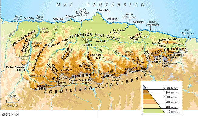
RELIEF OF ASTURIAS
COASTAL LANDSCAPES IN ASTURIAS
RIVERS OF ASTURIAS